Writer Clarence | by AfterPost | 18 October 26
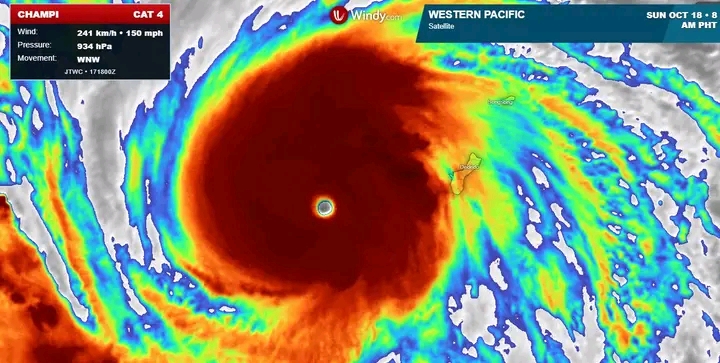
Super Typhoon Champi's perfect "pinhole" eye missed Guam's southern tip by just 10 miles early Sunday Oct 18, packing sustained winds of 150 mph, the equivalent of a high-end Category 4 hurricane. The storm became a super typhoon at closest approach at 4:26am local time, sparing Guam from a devastating direct hit.
Satellite imagery from Himawari-9 showed Champi's eye temperature warming to 20°C, a tiny 5-mile-wide clear center surrounded by very cold cloud tops. NWS Guam called it "extremely dangerous" and "life-threatening." Eye passed 10 miles south of Guam, moving west-northwest at 15-16 mph.
Guam got tropical storm winds, not typhoon. Airport gusts 80-85 mph, not 110-130 mph warned. No sustained 74 mph recorded at airport, Apra Harbor, Pago Bay. Southern villages nearest center have no sensors but likely saw gusts over 100 mph. 1-3 inches rain, not 8-14 inches forecast. Island-wide power outage warning remains.NWS Science Officer Brandon Aydlett: "It's really hard to underscore how close this was to being a significant and devastating event... very tightly compacted, but it would have been a devastating event if it had come on shore."
Why pinhole eye is INSANE and dangerous:
Pinhole eye = 3-6 miles diameter vs normal 20-40 miles. Means rapid intensification. Champi went from tropical storm to Cat 4 equivalent in less than 48 hours, from 130 mph Saturday evening to 150 mph Sunday. Dvorak T6.5-T7.0, ADT estimates supported upgrade to 130 kts super typhoon, 6th of 2026 season.Tight windfield: typhoon-force winds extend only 60 miles from center, but extreme gradient. Wind drops off quickly within 10-15 miles. Concentric eyewall seen on microwave, no eyewall replacement yet, radial outflow excellent, no shear.Pinhole storms wobble. 10 miles saved Guam. If it had shifted north, southern Guam would have seen 110-130 mph sustained, gusts to 160 mph. Venturing outside = death from flying projectiles, NWS extreme wind warning said.
What's next for Champi:
JTWC Advisory #9 Oct 17 00:00 UTC shows Champi moving away from Marianas, still 130 kts. Forecast track shifted southwest due to subtropical ridge building over Philippine Sea. Then turn west-northwest across Philippine Sea. Models agree until Luzon Strait. Toward end, ridge weakens, slows down. PAGASA says Champi 2,230 km east of SE Luzon Sunday 4am, winds 185 kph sustained, gusts 230 kph, moving WNW 25 kph. To enter Philippine Area of Responsibility Oct 20, will be named Rosal locally. Signal No. 3 or 4 possible for extreme Northern Luzon later this week. Taiwan track likely, low Philippines landfall chance.Guam and Rota under typhoon warning still, Tinian Saipan tropical storm warning. Governors requested emergency disaster declarations from President Trump. FEMA says resources 3-5 days out. Islands still recovering from Super Typhoons Sinlaku April and Bavi July.FAQ
What is Super Typhoon Champi pinhole eye?
Tiny 5-mile-wide eye with warm 20°C center seen on Himawari-9 satellite, sign of intense Category 4+ typhoon.
How strong was Champi near Guam?
150 mph sustained at closest approach, threshold for super typhoon, high-end Cat 4. Cat 5 starts 157 mph.Did Champi hit Guam?
.No direct landfall. Missed by 10 miles south at 4:26am Oct 18 local. Most of island got tropical storm conditions.Is Champi going to hit Philippines?
Not directly as of Sunday. Will enter PAR Oct 20 as Rosal, pass toward Taiwan. Extreme Northern Luzon may see Signal 3-4, heavy rain.Why is pinhole eye more dangerous?
Indicates rapid intensification, extreme pressure gradient, devastating winds in very small area. Hard to forecast wobble.Also read this: https://afterpostint.com/post/h2-strong-burkina-faso-develops-8-new-rice-varieties-with-nuclear-strong-h2